Elk River Hiking
Trail is a finalist because...the 15-mile National Recreation Trail, on the
edge of the Chautauqua Hills region, threads through boulders and up rocky
bluffs and has been rated the best hike in the state.
Location: The
trail is located at Elk City Lake which is approximately one mile west of
Independence, north of U.S. 160. The lake is operated by the U.S. Army Corps of Engineers.
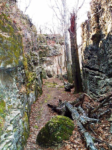
Photo courtesy kansastrailscouncil.org
NATIONAL RECREATION TRAIL The Elk River Hiking Trail has been designated as a National Recreation Trail under the U.S. Department of the Interior's National Trail System and Backpacker magazine has rated it the best hike in Kansas. The trail treats the walker to an adventure in southeast Kansas on the cusp of the Chautauqua Hills and Osage Cuestas region.
TRAIL DESCRIPTION The Hiking Guide to Kansas by Catherine Hauber & John Young describes the trail like this: "The trail, which winds along a rocky ridge on the north side of the lake, travels along sheer rock walls, under rock canopies, through rock tunnels and chambers, up rock steps to bluffs overlooking the lake, and around giant boulders, sometime balanced precariously on end in seeming defiance of gravity. We were fascinated by the mushroom-like rocks, table rocks, ledges, and a rock hollow carved by a small waterfall."
Excerpts from Hauber's description of the hike: "This trail is rated as rugged because of the rocky and sometimes steep climbs and descents on the ridge overlooking the lake. Just past the east trailhead, the trail crosses a creek on a board. As you climb the first of many switchbacks, you will see outcroppings of the incredible rock that sets this trail apart from all others in Kansas. As the trail nears the top of the ridge, it skirts caverns eroded from the bluffs, passing through rock chasms and into chambers. The woods along the rocky hillside are dominated by many varieties of oaks.
About 1.3 miles from the start, the trail climbs to a large table rock overlooking the lake. Occasionally, the trail leaves the woods and travels through prairie dotted with red cedar, woody shrubs, wildflowers, and even cactus. When the trail is not traveling along the bluffs over the lake, it often drops into scenic wooded valleys where clear creeks can cool hot, tired feet.
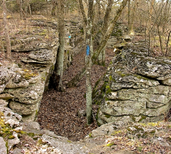
Photo credit Michael Goodwin
The 5.6-mile hike from the Oak Ridge Trailhead to the end is not as scenic overall as the first 9.4 miles but it has some singularly beautiful sections. A half mile past the trailhead, a large sycamore, which appears to grow out of rock, stretches over a mossy stream. From Oak Ridge to the end, the trail parallels and frequently climbs the bluffs for panoramic views of Elk River. A notable stopping point is a small waterfall, where water from the overhanging rock trickled into the rock hollow below. In the last two miles the trail climbs across rocks and drops into the old river channel. Watch for a small cave in the bluffs. About one mile from the end, the trail drops down to the river, one of the most scenic areas of the hike.
Courtesy of Hiking Guide to Kansas, here are trailheads for Elk River Hiking Trail: West Trailhead: Just off U.S. 160, about 2 miles south of Elk City.
Oak Ridge Trailhead: Located in the Oak Ridge Public Use Area. After turning at the park road on the northwest side of the project office, travel 4.75 miles to the trailhead. The trailhead is marked by a large sign, just off the road.
East Trailhead: Located about 100 yards south of the Corps of Engineers project office, about .5 mile northwest of the dam. From the turnoff on U.S. 160, travel 1 mile north to a T intersection; go west for .3 mile, then north for 1.5 miles where the road intersects with a road to the east. Curve west and travel west/northwest for an additional 3.3 miles across the dam and watch for the road on the northwest side of the project office.
The trail is 15 miles one way and is marked with blue paint blazes. There are two gravel roads between the trailheads to provide vehicle access to the trail for those desiring to establish water caches or walk only a portion of the trail. Camping is permitted in the general areas located directly to the west of the gravel access roads between the trailheads.
Source:Hiking Guide to Kansas by Catherine Hauber & John Young. Copyright 1999 by the University of Kansas Press.
For other good trails at Elk City State Park, click here. For more information about Elk City Lake, click here.